


The general purpose of the Geocromía Patagonia research project is to explore, through the intersection of different disciplines such as geology, art, and design, all with the common thread of color, elements, and materials from the landscape of the Aysén region.
As part of the actions taken to achieve this goal, from May 12 to 16, 2025, the central area of the Aysén region was surveyed, burying 31 cardboard boxes in 16 locations of special geopatrimonial value. In addition, samples of rocks and/or sediments were taken to make a technical characterization of the sites.
The numbers on the map correspond to areas known regionally as: 1) Stone Bridge; 2) Baño Nuevo Volcanoes; 3) Virgin Waterfall; 4) Alto Baguales; 5) Mac Kay Hill; 6) Chacano Bridge; 7) Traiguanca Bridge; 8) La Candonga; 9) Marble Caves; 10) Marble Quarry; 11) Mina Escondida; 12) Varve Deposits in Fachinal; 13) Piedra Azul; 14) Travertine Deposits; 15) Fénix Erratic Block; 16) Valle Lunar.
The study sites were selected from the regional geopatrimony inventory (Benado et al., 2020), considering the search for diversity in landscape, environments, and colors. The technical characterization of the rocks was carried out following the classification steps described in the “Methodology” section of the website. Specifically, transparent sections and microscopic analyses were provided by the Aysén Regional Museum.

Figure 1. Map showing the locations where the cellulose cardboard boxes were placed.
SELECTED LOCATIONS AND DESCRIPTION OF THE ROCKS
Puente de Piedra (Rock Bridge)
This is the area in the entire Aysén region with the most representative and largest “giant potholes” (Figure 2). This is an informal name used to describe large rounded depressions caused by the abrasive action of grains transported by water.

The rocks in the area are intrusive igneous rocks. They have an alteration color and a fresh surface color of brown and gray-white, respectively (Figure 3). The fresh surface shows a Leucacratic mafic mineral color index (15%). They have a holocrystalline, phaneritic, equigranular texture, with fine grains and subhedral shapes. The samples contain approximately 85% felsic minerals and 15% mafic minerals; specifically, they contain 45% quartz, 40% plagioclase, 13% biotite, and 2% opaque minerals (e.g., magnetite). Given the above and their major secondary mineral, the samples are classified as “biotite tonalite.”

Figure 3. Representative rock from the Puente de Piedra area. Image b) is a microscopic photograph, taken at 50X magnification, transmitted light, and crossed nicols.
Figure 2. Giant's kettles in the Puente de Piedra sector.
Baño Nuevo (New Bath)
They are a group of more than 50 isolated hills (Figure 4), remnants of explosive volcanism that occurred in the sea approximately 120 million years ago. These ancient volcanoes vary in size, some small, but others more than 1 km in diameter and up to 100 meters high, spread over an area of approximately 300 km2 of steppe.

With regard to rocks, the most representative are igneous pyroclastic rocks and lavas. The sample in Figure 5 has an alteration color and fresh surface, purple and purple-gray, respectively. The groundmass is mostly glassy and lithic, with amygdules filled with calcite, epidote, gypsum, and quartz. The types of pyroclasts present in the sample are:
-
Vitrioclasts: these are found in the fundamental mass, are purple-gray in color and ash-sized. In total, vitrioclasts make up approximately 40% of the sample.
-
Lithoclasts: purple-gray, subrounded, volcanic origin, lapilli-sized lithic fragments are observed. In total, lithoclasts make up approximately 50% of the sample.
-
Cristoclasts: phenocrystals are mainly filling cavities. They are calcite, epidote, and quartz, ash-sized, and gypsum crystals of lapilli size.
In total, the cristoclasts account for approximately 10% of the sample. Given the proportion and size of its pyroclasts, the rock is a “lithic lapilli tuff.” Alternatively, if it were considered lava, the sample would be an “Andesitic autobreccia.”
Figure 4. Volcanic remains of Baño Nuevo

Figure 5. Representative rock from the Baño Nuevo area. Image b) is a photograph of the sample under a microscope, taken at 16X magnification, transmitted light, and crossed nicols.
Cascada de la Virgen (Virgin´s Fall)
It is one of the most representative examples of waterfall-type morphologies (Figure 6) in the region, as well as a tourist icon on the route connecting the cities of Coyhaique and Puerto Aysén. The cause of these morphologies is still under investigation, but it is reasonable to assume that structural reasons are among the primary causes.

The most representative rocks in the area are intrusive igneous rocks. They have an altered color and a fresh surface, brown-black and pink, respectively. The fresh surface shows a leucocratic mafic mineral index (5%). They have a holocrystalline, phaneritic, equigranular, medium-grained, subhedral texture (Figure 7). They have a slight magnetism and some small cavities (less than 5 mm) with prismatic quartz minerals inside. Approximately 95% of the minerals are felsic and 5% are mafic. Specifically, approximately 45% is alkali feldspar, 45% is quartz, 5% is plagioclase, and smaller percentages are biotite, hornblende, and magnetite. Given the above and the classification triangle, the sample is an “alkali feldspar granite.”

Figure 7. Images of a representative rock sample from La Virgen Waterfall. Image b) is a photograph of the sample under a microscope, taken at 16X magnification, transmitted light, and crossed nicols.
Figure 6. Section of the area known as Cascada de La Virgen.
Alto Baguales (High Baguales)
It is one of the most representative examples of waterfall-type morphologies (Figure 6) in the region, as well as a tourist icon on the route connecting the cities of Coyhaique and Puerto Aysén. The cause of these morphologies is still under investigation, but it is reasonable to assume that structural reasons are among the primary causes.

Figure 8. Area of black hills known as Alto Baguales.
The rocks are detrital sedimentary rocks. They have an altered color and fresh surface, reddish-brown and iron-gray, respectively (Figure 9). They react strongly to hydrochloric acid, exhibit some magnetism, and are consolidated, making them difficult to break by hand but easily breakable with a hammer. In general, they are matrix-supported, composed mainly of matrix/cement and a small proportion of crystals. The matrix is clay-sized, iron-gray in color; the cement is calcite, and the presence of silica is inferred from certain conchoidal fractures. The crystals are mainly calcite and, to a lesser extent, pyrite. It is common to find fossil remains of bivalves, ranging in size from 2 to 20 mm. Given the above, the samples are “black fangolite, of marine origin, with fossil remains of bivalves and ammonites.”

Figure 9. Images of a rock sample representative of the Alto Baguales area. Image b) is a photograph of the sample under a microscope, taken at 50X magnification, transmitted light, and crossed nicols.
Mac Kay Hill
It is one of the most representative examples of waterfall-type morphologies (Figure 6) in the region, as well as a tourist icon on the route connecting the cities of Coyhaique and Puerto Aysén. The cause of these morphologies is still under investigation, but it is reasonable to assume that structural reasons are among the primary causes.

Figure 10. Image of Mac Kay Hill, in the city of Coyhaique.
The rocks on the hill are mainly subvolcanic igneous rocks. A representative sample (Figure 11) shows alteration color and fresh surface, green-brown and gray, respectively. The fresh surface shows a leucocratic mafic mineral index (15%), holocrystalline texture, phaneritic, inequigranular, medium to fine grain, subhedral. Quartz eyes and some mafic enclaves are observed. The latter range in size from a few millimeters to 2 cm and, locally, there is some magnetism. Approximately 85% felsic minerals and 15% mafic minerals are observed. Specifically, approximately 50% is quartz, 35% is plagioclase, no orthoclase is observed, 10% is hornblende (including some green acicular minerals), 4% is biotite, and 1% is metallic (probably magnetite and pyrite). Given the above, the sample is a “hornblende tonalite with a porphyritic texture.”

Figure 11. Images of a representative rock sample from Cerro Mac Kay. Image b) is a photograph of the sample under a microscope, taken at 16X magnification, transmitted light, and crossed nicols.
Puente Chacano (Chacano Bridge)
This is an area where the Ibáñez River has a geological fault, i.e., a fracture and relative movement of the terrain. This fault causes the watercourse to deviate in the form of a bend (90°), along with a narrow and deep incision in the rocks approximately 30 meters high (Figure 12).
The rocks are igneous pyroclastic. A representative sample (Figure 13) shows a color of alteration and fresh face, yellowish-gray and blue-gray, respectively. It shows magnetism and reacts, in specific areas, to hydrochloric acid. The types of pyroclasts present in the sample are:
-
Vitrioclasts: the fundamental mass is bluish gray and ash-sized; there are small fragments of black glass, less than 1 mm in size; there is abundant pumice, bluish green in color (probably chloritized) and lapilli-sized (approx. 3 mm); some quartz eyes can be distinguished. In total, vitrioclasts make up approximately 65% of the sample.
-
Lithoclasts: these are black, brown, red, and bluish in color, subrounded in shape, and mostly lapilli in size; they are inferred to be of volcanic composition. In total, lithoclasts make up approximately 25% of the sample.
-
Cristoclasts: these are mainly calcite, plagioclase and, to a lesser extent, hornblende, quartz and metallic; all cristoclasts are ash-sized. In total, cristoclasts make up approximately 10% of the sample.
Given the proportion and size of its pyroclasts, the rock is a “vitreous lapilli tuff.”

Figure 12. Image of the fracture in the Puente Chacano sector.

Figure 13. Images of a rock sample representative of the Puente Chacano sector. Image b) is a photograph of the sample under a microscope, taken at 16X magnification, transmitted light, and crossed nicols.
Puente Traiguanca
(Traiguanca Bridge)
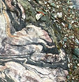
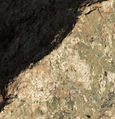
They are the only ultramafic rock formations (i.e., with very low silica content and more than 90% “dark” minerals) in the Aysén region and, specifically, they are the southernmost serpentinites in all of Chile.

Figure 14. Outcrop of ultramafic rocks in the Traiguanca River and bridge.
The rocks are very dark green in color. A representative sample (Figure 15) is fractured by a matrix filled with a brownish-yellow to light green material, with no crystals visible to the naked eye. Under the microscope, this sample is seen to be composed of approximately 89% massive serpentine, mainly antigorite and to a lesser extent lizardite, with undifferentiated zones; it also contains 6% carbonates (possibly siderite-dolomite) and 2% talc, both filling fractures, and approximately 3% disseminated opaques.

Figure 15. Images of a rock sample representative of the Puente Trianguanca sector. Image b) is a photograph of the sample under a microscope, taken at 16X magnification, transmitted light, and crossed nicols.
La Candoga
It is a very steep and large ravine (Figure 16) on the road connecting the towns of Bahía Murta and Puerto Eulogio Sánchez, characterized by Mesozoic granitoids with megacrystals of potassium feldspar.

Figure 16. Image of La Candonga Ravine.
The rocks are intrusive igneous rocks. A representative sample (Figure 17) shows alteration color and fresh surface, brown-yellow and gray-pink, respectively. The fresh surface of this sample has a color index of leucocratic mafic minerals (8%), a holocrystalline, phaneritic, inequigranular, coarse-grained texture, and subhedral forms. It exhibits some magnetism and some clusters of mafic minerals. Mega crystals (greater than 5 cm) of potassium feldspar are observed. The sample contains approximately 92% felsic minerals and 8% mafic minerals. Specifically, 40% are potassium feldspars, 30% plagioclases, 22% quartz, 7% biotites, and 1% metallic. Given the above and its texture, it is classified as “Monzogranite with mega crystals of potassium feldspar.”

Figure 17. Images of a rock sample representative of the La Candonga sector. Image b) is a photograph of the sample under a microscope, taken at 16X magnification, transmitted light, and crossed nicols.
Cavernas de Mármol (Marble caves)
These are marble rocks with karstic relief (Figure 18), meaning that they have cavities caused by the dissolution of carbonate in the water of Lake General Carrera. They are the only outcrops of this type in the entire Aysén region.

Figure 18. Karst relief in the area known as the Marble Caves.
Figure 18. Karst relief in the area known as the Marble Caves.
With regard to the rocks, a representative sample (Figure 19) is carbonated, with an alteration color and fresh surface of lavender gray and bluish gray, respectively. It reacts abundantly to hydrochloric acid. It does not show foliation, and bands with white and gray colorations are observed, along with irregular areas of brown-orange color. It is composed of fine-grained calcite crystaloblasts. Under the microscope, it can be seen to consist of an aggregate of granoblasts, approximately 97.5% calcite minerals, which occur in bands of very fine to somewhat coarser grains, consequently with more gray and white colorations, respectively. Given the above, the sample is classified as “gray marble.”

Figure 19. Images of a rock sample representative of the Cavernas de Mármol sector. Image b) is a photograph of the sample under a microscope, taken at 16X magnification, transmitted light, and crossed nicols.
Cantera de Mármol (Marble Quarries)
It is a textbook area for studying the tectonic forces that have affected Patagonia over the last 300 million years. In addition, it is an area of cultural value, as local artisans extract marble raw materials from there to make handicrafts.
The rocks in the quarry are similar in composition to those in the marble caves (see site 2.9), but they do not have karst morphology.
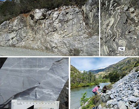
Figure 20. Images of the area known as Marbe Quarries
Mina Escondida (Hidden Mine)
These are the remains (Figure 21) of an old copper and lead mine in the hills immediately south of Puerto Guadal. The mine was active, albeit intermittently, between 54 and 86 of the past century.

Figure 21. Images of the industrial remains of the old La Escondida mine.
With regard to the rocks, a representative sample (Figure 22) has a brownish-yellowish-orange color due to the possible presence of Fe oxides. It has a brecciated texture, with fragments of foliated texture of metamorphic origin, alternating light gray and dark brown bands. The matrix of this breccia is whitish in color and consists of massive quartz with the presence of metallic mineralization, with pyrite, sphalerite, chalcopyrite, and pyrrhotite among the most abundant minerals.

Figure 22. Images of a rock sample representative of the La Escondida mine.
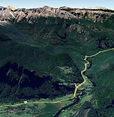
Depósitos de Varves en Fachinal Varve deposits in Fachinal
These are the thickest varve deposits (Figure 23) in the entire region. These varve deposits originated from the accumulation of fine sediments in the deep parts of proglacial lakes or in subglacial lacustrine environments.

Figure 23. Image of a road cut in the Fachinal area, composed of glacial varves.
According to SERNAGEOMIN (2011), the ceilings of the deposits contain millimeter-sized freshwater gastropod fossils, and X-ray analysis of the silt revealed a composition of quartz, plagioclase, and vermiculite.
Just as tree rings reveal the age of a tree, a black layer followed by a white layer of varves indicates one year of the presence of an ancient glacier in the area. Specifically, the varves in the Fachinal area mainly show horizontal lamination, folds, and synsedimentary faults; locally, there are inclusions of gravel and subrounded blocks that are usually interpreted as debris discharges from floating ice in a glacial lake.

Figure 24. Lamination in the varve deposits of the Fachinal area.
Piedra Azul (Blue Stone)
It is an iconic rock and landmark in the city of Chile Chico. Its origin dates back 150 million years, when Africa and South America began to separate; its characteristic rounded shape (Figure 25) is the result of the passage of ice over the last million years; the community has recounted its use as a hideout in the so-called “Chile Chico War” of 1918.
Regarding its rocks, a representative sample (Figure 26) corresponds to an igneous pyroclastic rock. It has an alteration color and fresh face, gray-whitish and gray-green, respectively. The fundamental mass is vitric, with abundant fiammes observed. Specifically, the types of pyroclasts present are:
-
Vitrioclasts: the fundamental mass is yellowish-brown, ash-sized; there is abundant pumice, gray and green in color, ranging from 2 to 20 mm, with a mode of 5 mm. Under a magnifying glass, small pieces of glass, less than 2 mm in size, can be observed. In total, vitrioclasts make up approximately 55% of the sample.
-
Lithoclasts: fragments of volcanic rock are observed, green, gray, and brown in color, lapilli-sized. In total, lithoclasts make up approximately 35% of the sample.
-
Cryoclasts: these are mainly plagioclase and quartz and, to a lesser extent, red minerals, all less than 2 mm in size. In total, cryoclasts make up approximately 10% of the sample.
Given the proportion and size of its pyroclasts, the rock is a “vitreous lapilli tuff.”

Figure 25. Panoramic image of Piedra Azul.

Figure 26. Images of a rock sample from Piedra Azul. Image b) is a photograph of the sample under a microscope, taken at 16X magnification, transmitted light, and crossed nicols.
Depósitos de Travertinos (Travertine deposits)
Located immediately southeast of the city of Chile Chico, these are the only travertine outcrops, identified as a geological unit, in the Aysén region. In general terms, “travertine” is a term used for sedimentary rocks of chemical origin, from limestone of inorganic sources
These travertines are a surface covering or crust (Figure 27), approximately 15 ha in area, over a group of small ravines, which together form a topographic high point with a N70°W orientation.

Figure 27. Images of travertine deposits.
Specifically, the travertine samples correspond to an orthochemical non-clastic sedimentary rock, with an alteration color and fresh face, gray-blackish and gray-yellowish, respectively. It reacts strongly to hydrochloric acid; it does not exhibit magnetism; it is consolidated, cannot be fractured by hand, but is easily broken up with a hammer. No crystals are visible, and the grains are mud-sized, mostly silt, and it is porous and abrasive. Abundant forms (molds and impressions) of ancient organic material are observed, for example, roots, stems, and leaves, along with local banding of different shades.
Under the microscope (Figure 28), it can be seen that the sample consists almost exclusively of calcite (approximately 99.7%), together with very small percentages of quartz, albite, and illite, the latter two filling pores. The calcite forms the cement and is generally botryoidal in shape, with radial growth and central moldic porosity.

Figure 28. Photographs of travertine samples. Image a) corresponds to the hand sample; image b) is the reject; image c) is a microscope photograph, taken with transmitted light, crossed nicols, and 100X magnification.
Bloque de Fénix
(Fenix Block)
It is a very representative example of an erratic block, that is, a large rock transported and left in a different context by ancient glaciers. Specifically, this block is approximately 16–7 million years old and would have been dragged by glaciers approximately 8 km eastward between 23,000 and 16,000 years ago.
The block is roughly rectangular in shape, with an approximately square base measuring about 12 m on each side and a height of 18 m. It is heavily jointed, both vertically and horizontally, giving it a fractured or brecciated appearance.
The rocks are extrusive igneous, with alteration color and fresh surface, brown and black, respectively. The fresh surface shows a mesocratic mafic mineral color index, with a hypocrystalline, aphantic texture, practically indistinguishable to the eye, except for small elongated amygdules filled with milky-colored minerals. Among the few crystals distinguishable under the magnifying glass, plagioclases, olivines, and pyroxenes can be observed; it exhibits magnetism. Under the microscope (Figure 30), it can be seen that the phenocrystals are 2% pyroxenes and 11% olivines, while the matrix is composed of 28% plagioclases, 23% pyroxenes, 4% opacifiers, and 24% glass. Given this, the rock is classified as “olivine basalt.”


Figure 30. Photographs of a sample from the Phoenix Block. Image b) is a microscope photograph, taken at 16X magnification, transmitted light, and crossed nicols.
Figura 29. Bloque de Fenix Image.
Valle Lunar
(Lunar Valley)
It is a very representative and well-preserved example of the products of a volcanic dome (Figure 31). This dome collapsed approximately 150 million years ago.
Its rocks have varied colors (Figure 32), mostly white-greenish, white-grayish, greenish, and reddish, which tend to attract the attention of visitors. An analysis of a hand sample allows us to conclude that these rocks are lapilli tuffs of variable composition (vitreous, crystalline, or lithic). In addition, it is recognized that the whitish samples are more abundant in silica, the greenish ones are abundant in chlorite-smectite, and the reddish ones appear to have large amounts of limonite; these observations must be corroborated in the laboratory.


Figure 32. Photographs of representative rocks from the Lunar Valley. a) greenish white sample; b) grayish white sample; c) green sample; d) reddish sample.
Figure 31. Image of the Lunar Valley, from the Jeinimeni River valleys.